Soapstone Prairie Natural Area: Where Bison and Coloradoans Roam
Soapstone Prairie Natural Area, located approximately 25 miles north of Fort Collins--an hour's drive including the 13-mile stretch of dirt road--is Fort Collins' best kept secret! The drive to Soapstone Prairie is an experience in itself, and helps build up the anticipation of the endless vistas to come. You'll glimpse the sudden swells of grassy knobs, gulleys cutting through the prairie, cows, pronghorn, rabbits and bison, and an open sky.
Once there, you'll discover a web of 44 miles of trails to venture along over the 28 square miles of the natural area covers--be it on foot or horseback, or by bike, for a quick one-hour hike, or a longer full day of adventure! Just be sure to bring lots of water, sunblock and a map.
(Lonas, 2016)
So what is unique about Soapstone Prairie Natural Area?
Its History!
Soapstone Prairie is an important archeological site not only where the discovery of Folsom points led to “re-writing the human history of the Americas” as it was understood in the 1900’s (Martin et al., 2009, p. 8), but also where you can see artifacts of more recent inhabitants, including the Ute tribe, early settlers, homesteaders and ranchers.
The archaeological site is visible looking southwest from the overlook. And while other prehistoric campsites at Soapstone aren't marked, keep your eye out for the numerous stone circles and stone artifacts found here, some of which are close to 4,000 years old.
Other historic sites mentioned in the Soapstone Prairie Natural Area Management Plan (2007) include the Welch dugout; the remains of old stone structures, including an old schoolhouse; and the remains of the Lindenmeier, Guy and Taulman homesteads. Photographs of each historic site can be found here in the management plan on pages 33 to 39, and a map showing the location of each place is included on page 105.

Its Ecosystem and Geology!
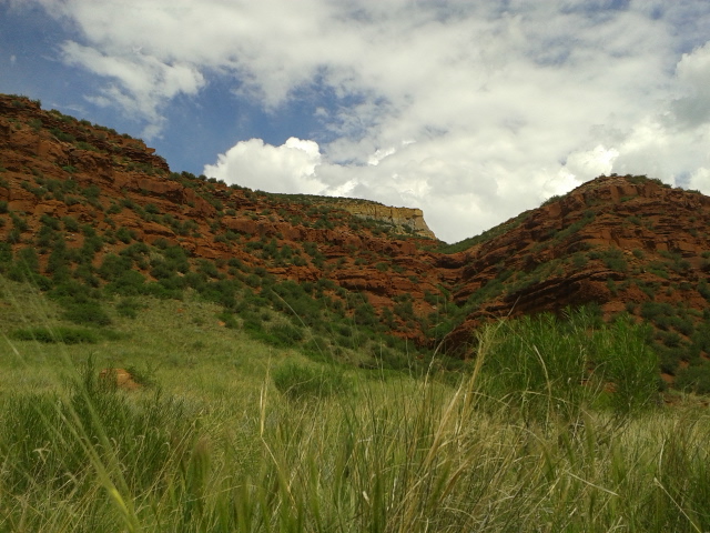
Just as much a part of its history is Soapstone's Prairie's ecosystem and geology! The Soapstone Prairie is home to a unique ecosystem including a variety of flora and fauna that while at risk of either complete or regional extinction, are indigenous to the foothills and the plains of Northern Colorado. Additionally, it is an area for geology lovers. The rock formations found at Soapstone span 300, 000, 000 years and include conglomerate, multi-colored mudstone, red and gray sandstone, siltstone and limestone.
While much of the land at Soapstone is prairie, and so much of the geological history of the area is not as visible as at the adjacent Red Mountain Open Space, there are surprise pockets of the different formations along the paths. You can read more about and see pictures of the flora, fauna and geology in the Management Plan (2007) here on pages 6 to 9.

Its 44 miles of Trails!
And last but not least, Soapstone Prairie is a great place for recreation and to create your own history of adventures. The jaunts up and down the rolling prairie lead you to open vistas from the hilltops and nobs to sweeping valleys and shallow canyons.
The well-maintained trail system offers internal trails for shorter hikes and longer trails that skirt the outer edges of the open space both on the east and west. The Cheyenne Rim trail, which begins at the horse trailer parking lot to the east of the park entrance, connects to the Red Mountain Open Space trail system (and 20 more miles of trails!) just to the west. Cheyenne Rim is perfect for a trail run or ride that can range from meandering to vigorous.

Two Recent Visits
The First Visit
The plan was to go on an easy hike and have a picnic for my birthday. My mother, who was visiting from Washington, D.C., loves history, nature and hiking, so it seemed like the perfect destination. The day started out cloudy, but with little menace of it worsening--until we got to Soapstone and parked the car. We saw the mass of gray approaching from the east, and heard the frequent rumblings.
We decided that we at least would have time to go to the Lindenmeier site. As we followed the paved trail to the site, my mother was in awe of the panoramic view and the variety of wildflowers growing along the path, and of the bird songs distinct from those she hears on the East Coast.
At the Lindenmeier overlook, we looked at the replicas of Folsom Points, read the plaques, and watched the fast-moving storm as it settled in overhead. We decided to wait the storm out rather than risk the walk back to the car, so we hunkered down on the concrete floor for our picnic, and listened to the surround-sound thunder, and watched the lightning show and rain. The changing shades of grey of the storm clouds, and the softened green of the prairie behind the gauze-like sheet of rain were spectacular, but the concrete floor after an hour was cold...so when there was a lull between the first storm and a second storm also approaching from the east, we decided to return to the car.
Sadly, my mother wasn't able to see the views from along the other trails. But I know exactly where to take her on her next visit!
(Lonas, 2016)
The Second Visit
Two weeks later, I returned with a friend. We got an earlier start, under a blue sky spotted with white, puffy clouds. We meandered over the first ridge, fascinated by the mix of vegetation, the variety of bird calls, the wildflowers and the open, endless vistas. We followed the trail as it coursed over a second hill and then down into a sweeping long valley and met up with Canyon Trail--the only sign of civilization at this point was us. The grass is tall enough along Canyon Trail to tickle your fingertips as you walk, and the trail, in coursing along the length of the valley, gave way to blue sky toward the east.
And then the signature rumbling of thunder came from behind the hills to the west, and we saw that the white puffy clouds were giving way to a gray mass. But even that transformation fascinated us--the varying layers of clouds merged and overlapped, metamorphosing above us and darkening the green of the prairie behind us. We were too happy to turn back, so we continued along, stopping to eat lunch and continue watching the cloudplay overhead.
Within a few minutes of finishing lunch we felt the first drops, but hoping for the best, we refused to pick up the pace.
And as we rounded the bend, we encountered another reason to refuse to give in to the storm--a completely unexpected geological change. The low shrubs were now broken up by massive, gritty boulders that looked like they were covered with the impressions of thousands of fingerprints; and following, a soft, chalk-like earth; and following that, rock formations composed of hundreds of pebbles embedded in a crustacean-like mortar that looked almost like coral.
Oddly, it was at this point that the storm clouds suddenly shifted north, taking the lightning and rumbling thunder with them. We continued our hike back to the car, to then go explore Red Mountain Open Space--the other best kept secret of Fort Collins!
 (Lonas, 2016)
Your recent visits!
In the space provided at the bottom of the page under 'Leave a Reply', feel free to include descriptions and stories of your own recent visits to Soapstone Prairie...
General Information
How to Get to Soapstone Prairie...
From North College Avenue, turn right onto Terry Lake Road and continue north. Turn left to continue north on Terry Lake Road/ CR15.
You'll pass Waverly, and continue on CR15 until you come to Rawhide Flats Road/ an intersection with CR84. There will be a sign to turn left on CR84 toward Red Mountain Open Space (17 miles), or north on CR15 to Soapstone Prairie (13 miles).
At this point the road becomes a dirt road--at times very bumpy. Please go slowly and watch out for the rabbits that often sit along the edge of the road.
Once you get to the park entrance, you can opt to go left, to begin on the Cheyenne Rim Trail, or straight to the Lindenmeier site and the other multiple trailheads.
Click here for a road map of the area.
The Return Trip...
If you have the time to take the scenic route back, on coming to the intersection with CR84 and CR15, turn right onto CR84, and after a mile, left on CR 19.
After another mile, you'll come to CR80, which meanders back to Highway 287, where you'll turn left to head back to Fort Collins. The views along CR80 of the mountains to the west are worth the longer ride.
Permissible Activities and What to Bring...
Trails...
Some of the trails at Soapstone have restrictions, so be sure to check out the official website for trail updates. In general, the trails are open to hiking and biking, but equestrians must begin at the South Trailhead where the parking lot for horse trailers is located. Also, the Towhee Trail, which connects Canyon Trail and Mahogany Trail, is open only to hiking.
Weather...
The weather can change very quickly at both Soapstone Prairie and the nearby Red Mountain Open Space. Please follow the necessary precautions in the event you are caught in a lightning storm. (But stick around for the rainbows!)
Otherwise, wear sunblock, a hat and carry adequate hydration with you. There is no shade along any part of the trail.
Other Restrictions...
Stay on the trails to preserve the fragile environment and to reduce the likelihood of encountering rattlesnakes. However, rattlesnakes can be found on the trails--be aware and give them a wide girth.
No dogs are allowed at Soapstone Prairie or the nearby Red Mountain Open Space.